top of page

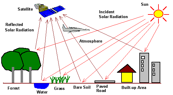
Remote Sensing is a technology used to take the positional information of an earth object without making actual contact with the help of sensors placed on satellites, aircraft or UAVs. The sensor collected information in the form of imageries which enable manipulation, analyze and visualize the earth objects in a more realistic manner. we are expertise in Hyper-Spectral, Multi-Spectral, Thermal and Panchromatic image processing. Utilizing the Remote Sensing service for rapid and precise assessments of spatial object saves the cost, time and avoid manual ground survey. 

Remote Sensing Services

 We offer following Remote Sensing services

  •   Aerial Triangulation (Satellite,Aerial and UAV)   

  •   DEM generation

  •   Land Used / Land Cover Mapping

  •   Change Detection

  •   Image Classification / Panshapening

  •   Raster Mosaic 

  •   Disaster Mapping

  •   Watershed Modeling

  •   Forest Resource Mapping


with-one-hand-holding-up--globe-icon-93998.png

Office Address

Head Office

INDIA

No 63, Bashyam Nagar,          Chromepet, Chennai,
Tamilnadu - 600044.

Regional office - Spatialwings

UAE

office no: 39, Spatialwings Drone services,

Al Karama, Dubai 

   Our Strength

  • Standard Processing System

  • Quality and Cost-effective

  • Solution through Latest Technology

  • Confidential and Data Security

  • 24 X 7 Support

Contact Us
 

Email : admin@spatialmates.com


Phone : 

            +91 8056576056

            +971 545740790

            +91 9344751825


To subscribe our Social Media for information 

  • LinkedIn - Black Circle
  • Facebook - Black Circle
  • Twitter - Black Circle
  • YouTube - Black Circle

All Rights Reserved © 2025 by SpatialMate Consultancy pvt ltd.

bottom of page